
Maps
Smoky Canyon Mine Area Map – depicts current mine area on a topographic map with annotation of A-E Panel and Overburden Disposal Areas (PDF 621K)
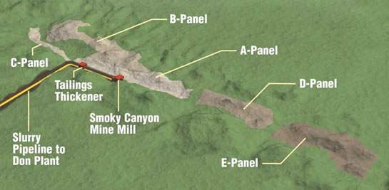
Smoky Canyon Mine Site Layout Map – Topographic map identifying Smoky Canyon Mine panels A through G, main structures, and pipeline. (PDF 712K)
DEIS Study Area – depicts areas F & G involved in Draft EIS. Map has 4X zoom with control panel at map bottom.
Panels F & G Map – depicts lease panels F & G area of operation on a topographic map. Zoom controls are on the bottom.
Vicinity Map – depicts the location of mine area in Eastern Idaho with insert showing location in Western United States (PDF 534K)
Geological Features Map – depicts the geological features for the mine area. (PDF 2,687K)